Friday, April 20, 2012

Tikona Fort Pune

For the past couple of months we were planning an outing and the gang was supposed to come from Mumbai to Pune for a booze party then next day go for a trek to Rajgadh. As planned things were going as usual but the booze party lasted quite sometime and the scheduled plan to wake up early at 5 a.m. and start for Rajgadh never materialised. By the time we woke up it was 10 a.m.

The gang comprised of Nimesh, Nishil, Ninad, Dhaval, Jignesh and myself. Leaving for Rajgadh at that hour was not a good idea so we quickly changed the plans and decided to go to Tikona fort. I was still feeling the whisky running through my veins and the bright sunny day was not much inviting for a trek. However, we decided to move on and started from our place at 11.00 a.m. By the time we refuelled and bought foodstuff to carry , it was already 12 noon.

I decided to take the Hinjewadi route via Godambewadi upto Paud and drive North-west to the fort. This became the first mistake of this trip. The road conditions were very bad all the way upto Paud. The roads are very narrow and make overtaking a difficult task. If you are unlucky to get stuck behind a tractor or truck, getting off the road to overtake is the only option. Not that the road is in good shape, but your vehicle will take more beating doing so.

After painfully making my way through the bad roads we finally reached the Javan junction. From here there is a slight uphill drive and on this road you can clearly see the fort to your right. We kept on moving ahead to find the road leading to the fort. The road goes all the way such that you end up almost making a semicircle around the fort after which a right turn indicating Tikona fort arrives.

Here onwards is a kutchha road and it's better to drive cautiously. After driving for few minutes I was wondering if we are on the right track. The place is quite remote and there was no one around to ask for route. After driving along this dust road, we reach the base of the fort where we could see a few cars parked and most of the people were on their way back.

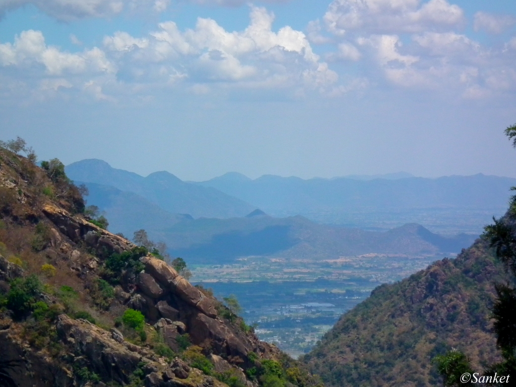
Hill opposite to Tikona
After parking and having eating few goodies, we started our trek. It was clear that there was no lunch today when I also realised that I was wearing my local floater sandals, hangover!. The trek looked pretty decent but the afternoon heat was draining us off.


Fort visible on top


Parking area 

After trekking for few minutes we reached a point from where the parking area was visible. This place will all green during monsoon and if using proper trekking gear and safety would be a nice trek. While trekking my sandals were not very helpful and I was finding it difficult to maintain proper grip so I decided to stay back. Dhaval who was already tired as usual was more than happy to see me return back to the half way point.


Slippery road to the top
The rest of the guys carried on all the way to the top. After waiting for few minutes at the midway point, Dhaval and myself returned back to the car and waited for the guys to return. Tikona still remains on my list and next time proper shoes would be  a point to remember.


Best time to visit: Nov to Feb

Duration:
Half to One day trip

Things to carry:

  • Food
  • Water
  • Basic first aid
  • Torch
  • Lighter

The place quite remote and it's better to carry essential medicines along.

Route Map:
Decided to take the route via Hinjewadi. Looked a shorter route, but the road conditions is just too bad to drive on. On the way back took the Paud road to make the drive a bit better.


View Larger Map

Best Route:
This is probably the best route based on travel time and road conditions. If you are staying in the heart of city, you can take the Paud road route.


View Larger Map


Monday, April 16, 2012

Chintamani Ashtavinayak Temple, Theur

The fifth of the eight Ashtavinayak

About:

Abhijeet was a great and powerful king who had everything in life except a son who would be the heir to his throne. The king and his wife at the suggestion of Rishi Vaishyampayane carried great penance and were finally rewarded with son who they named Gana. He later came to be known as Ganaraja.

The son was bright brave and gifted but was also very aggressive. Ganaraja was once invited to visit the ashram of Sage Kapil. The sage was a good host and with the help of the Chintamani Ratna (a precious stone) he was able to serve the best of food to Ganaraj. Impressed by the ratna, Ganaraj wanted it for himself, but when Kapilmuni refused to part with the ratna, he forcibly took it away from him.

Goddess Durga advised Sage Kapil to seek the help of Lord Ganesh. Lord Ganesh responded to his call and battled with Ganaraj under a Kadamba tree and managed to get the ratna back for Kapilmuni. However, Kapilmuni had lost all desire to possess the Chintamani ratna and he offered it Lord Ganesh. He tied the Chintamani Ratna around Lord Ganesha's neck and so he came to be known as the Chintamani Vinayak. Since all of this occurred under a Kadamba tree, Theur was also known as Kadambanagar.

The temple entrance is North facing and the outer wooden hall was built by Shrimant Madhavrao Peshwa. The main temple is supposed to be built by Dharanidhar Maharaj Dev from the family-lineage of Shri Moraya Gosavi approximately 100 years before the wooden hall was built.

The construction of the temple is very strong and throughout it's 400 years of existence, the structure has stood the test of time. There is  a big 5 metal bell, one of the 2 bells bought from Europe in the temple premises.

There is garden dedicated to wife of Madhav Rao Peshwa who went sati after Madhav Rao's death. Due to time constraints, I did not check the garden.

Places Nearby:


Duration:
Half a day trip

How to reach:
The temple is very close to Solapur Highway and can be reached from various directions.
I had combined the visit to this temple with Ranjangaon Mahaganapati and covered Theur on my return journey from Ranjangaon. The two places can be covered comfortable in half a day.

Once you are near the temple premises, there is an allocated parking in the same lane as the temple. It took me  a few minutes to spot the parking lot as the area near the temple is flocking with visitors and flower vendors. There is a small board indicating the parking area and can be seen if watched closely.

There is a small eatery inside the temple premises offering full meal at Rs.15 sponsored by some trust. The food is decent enough for the cost. You can also buy prasad at the counter in the temple premises.

Route Map:
Have marked the temple on the map, the route is one which I took for combined trip covering Theur and Ranjangaon.


View Larger Map

MahaGanapati Ashtavinayak Temple, Ranjangaon

The eighth of the eight Ashtavinayaks

About:

Lord Shiva is believed to have worshipped Ganesha before fighting the demon Tripurasura here. The temple was built by Shiva where he worshipped Ganesha, and the town he set up was called Manipur which is now known as Ranjangaon.

The idol faces the east, is seated in a cross-legged position with a broad forehead, with its trunk pointing to the left. It is said that the original idol is hidden in the basement, having 10 trunks and 20 hands and is called Mahotkat, however, the temple authorities deny existence of any such idol.

Constructed so that the rays of the sun fall directly on the idol (during the Southward movement of the sun), the temple bears a distinct resemblance to the architecture reminiscent of the 9th and 10th Centuries and faces the east. Shrimant Madhavrao Peshwa used to visit this temple very often and built the stone sanctum around the idol and in 1790 A.D.


Places Nearby:

Duration:
Half day trip

How to Reach:
The temple is adjoining the Nagar road highway as soon as you enter Ranjangaon from Pune. If you are travelling from Pune, the temple is to the right -side of the road. Ample parking space available near the temple. The temple has also undergone renovation work and new entrance door which can be seen from the main road is under construction.

The Nagar road is tolled road and will cost you Rs.57 to-fro for the trip.Road condition is good overall and there are no left and right on way to the temple.
The proximity from Pune makes it a comfortable half-day trip.

Route Map:
Have marked both Ranjangaon MahaGanapati and Theur Chintamani on the route map.

View Larger Map


Monday, March 5, 2012

Chikka Tirupati Near Bangalore

About:
As the name suggest , this is the miniature version of the Tirupathi Temple, 'Chikka' means small in Kannada. This temple lies very close to Sarjapur and is easily accessible from Bangalore. The roads overall are good from Sarjapur route with some bad patches. As all the temples in South India this too has beautiful gopuram and is peaceful place devoid of large crowds.

There is also this story about why this temple was built. It was built by Lord Agni to please Lord Vishnu. Agni deva was suffering from severe stomach ailment. Lord Brahma advised him to consume the herb-rich 'Khandava' forest to cure his ailment. However, Takshaka the Serpent-king and a close friend of Lord Indra , was residing there. Whenever Agni tried to consume the forest, Lord Indra’s thundershowers quickly extinguished the fire. With the help of Sri Krishna and Arjuna, Agni managed to consume 'Khandava' forest. During this, he caused injuries to Takshaka who cursed Agni that he will lose his 'teja'. 

To get rid of this curse, Lord Krishna suggested Agni deva to please Lord Vishnu who could return back Agni deva his 'teja'. Agni to achieve 'shaapa vimochana' built this temple of Lord Venkateshwara to please Lord Vishnu who returned back 'teja' to Agni Deva. The Lord here is also called Prasanna Venkateshwara for this reason.

Best time:
Throughout the year, an hours drive from Bangalore.

How to reach:
From Silk Board: 33 kms approx
Take the outer ring road to get to Sarjapur road. Continue on this road, till you reach Sarjapur. Its a pretty small town. Once you exit Sarjapur, there is a Y-Junction where you need to take a left and continue for another 10 kms and on the left hand side you should see the temple.

From Electronic City:
Take Hosa road to join Sarjapur road and continue with the same driving Directions as above

From Marathalli:
Take the Whitefield road and continue on the Bagalur road, NH 207

Route Map:
From Silk Board


View Larger Map

Monday, February 27, 2012

Mangal Murthi Morya Ganapati Temple

The Mangal Murthi Morya Ganapathi  also know as Birla Ganapati is a staggering 54ft tall Ganapati statue just off the NH4, Mumbai road near to the Somatane toll gate. It's a difficult to miss statue as this place is well lit up at night too. The idol is visible from the NH 4\Old  Mumbai-Pune road to the left if you are travelling towards Mumbai just as you approach the Somatane tollgate.

The majestic Ganesh Idol

How to reach:
If you are travelling from Pune, take the old Mum-Pune road(NH4) and go till the Somatane tollgate. On the left hand side you should see the beautiful Ganesh Idol on a small hillock. The entrance to the temple is right after the tollgate and if you are travelling by car, you need to pay a toll of Rs.26.

The stairs to the temple


Right after you cross the tollgate , there is a left turn almost like a V-turn. You can see a big board for Prati Shirdi which is on the same road about 1.5 kms from this junction. After you take the turn, after about 500m there is a small road climbing up to the left leading to the parking lot of the temple. There is a board with 'Mangal Murthy Morya Temple' indicating the left turn. There is ample parking space once you make your way up and they charge some nominal amount for parking. I had to pay Rs.3 for my two wheeler. Then you have to walk up the stairs to the temple. The climb is pretty easy and even elders and children will enjoy it. The place is kept very clean and secured with cctv cameras.

View from different angle

Best Time to visit:
Morning or evening, any day of the year. Morning 10 am should be a good time as the Idol is facing North-east and the light conditions would be better to take a clear shot at this time. The idol is not covered so visiting the place is monsoons might not be a good idea. I went to this place at 5 in the evening and could not get clear photos as the sun shining right behind the Idol. However, it is a good peaceful place to be with your family in the evening.

Places nearby:
The Ghorvadeshwar Cave temple is just about a km apart and can be covered on the same day.
Pratishirdi at Shirgaon is on the same road some 3-4 kms ahead.

Route Map:

View Larger Map

Ghorvadeshvar Cave Temple


If you are looking for a quick trek to a nearby place, why not combine it with visit to a temple. Ghorvadeshwar Cave temple is a active Shiv temple on top of a hillock just before the Somatane Toll gate if you are going towards Mumbai. A short walk up the stair will take you to these old caves. The view from the top is quite nice and on regular days the number of visitors is also not high making it an ideal evening destination. I could not make it to Shiv temple on MahaShivratri hence had planned to go to this temple on Sunday.

Temple arch

Best time to visit:
Any day of the year, preferable morning or evening to avoid afternoon heat.

How to Reach:
The Temple is very near to Pune and just about 800m before the Somatane Toll plaza on old NH4 road. There is no distinct marker for this temple but if you are traveling towards Mumbai, the temple will be on the left hand side of the road. Look out for arch and stairs when you start approaching the Somatane Toll gate. Also there is a big water tank on the right hand side which is just a few meters after the temple entrance but to the left. There is ample space for parking your vehicle and there is a small dhaba where you can have snacks. The main stairway of the temple is a few meters away from this dhaba and is uphill. I parked my bike right next to the dhaba. An old man keep a watch on the bikes and charges Rs.5. You can also park your bike right next to the stairs leading to the temple but i preferred it next to the dhaba. Cars can park right next to the dhaba as there is enough of open space.


On way to top

The water tank on the other side of road- marker
 
Going to the top:
To reach the temple you need to climb the stairs which then lead to rough terrain again joining the stairs. The initials stairs are quite good but elders might find a difficult time as the steps are quite big. Once you reach the end of these stairs there is a small flat top from where you can see the highway and the Birla Ganapati at some distance. Good place for few snaps. There are no stairs here. Climbing uphill you will eventually get to the stairs but this time the stairs are not that good. I followed the stairs whic lead me to a path, quite easy to follow and not that difficult and eventually got to the temple.

Birla Ganapati as seen from top
On the kutcha stairs, flat top seen below


Once you reach the top there is a junction and here is where there are two ways- left Vitthal Temple and right Shiv temple. Though I am not 100% sure of which deity was in the temple to the left but as far as my knowledge in mythology and gods it was Vitthal. 

Cave next to Shiv temple
Shiv temple
You can either start you way back after seeing the temple or make your way to the top. There are different routes you can take, one is right next to the temple a small narrow path. There is also a way marked with arrows right at the junction of two temples. This one is a bit difficult to climb as there is no clear path, just rocks. I made my way up this path and reached a point from where I could see the Mumbai-Pune Expressway and the new stadium. The way up is however steep and families definitely need to avoid it as the descent is a bit tricky. The view from this place is awesome but the time I went, 4 p.m. was wrong and I had the sun shining at my lens, so could not get clear shots. After seeing around and getting a couple of shots I made my way down, a bit tired but happy to have visited the Shiv temple and I could not go to a Shiv Temple on Mahashivratri.

The marked path up the hill

This is how it looks like once you climb up

The Xpressway and Stadium from the Top
Places Nearby:

Route Map:


View Larger Map

Saturday, March 12, 2011

Kolli Hills Tamil Nadu

Kolli Hills 'Mountains of Death'
It was a usual Sunday when I was surfing the net at home looking for new destinations to ride to when I came across Kolli Hills. What caught my eye was '70 hairpins'! The best I had heard in South India was Ooty with 36 hairpin bends and this one is no doubt just double. The destination was set, and too add to the excitement Kolli Hills is also know as 'Mountains of Death'. The much spookier name is not due to the roads but due to local folklore of a maiden luring travellers with her beauty and killing them! Yeah, I know sounds spooky, you go to save some damsel in distress and get killed!

View off Kolli Hills


The ride was all set for weekend of 12 March. As usual one call to Arun aka Bevda and he was ready to join in.We started a bit late as usual at about 7 am from Bangalore. The ride till Salem was smooth also the roads were very familiar as this patch had been covered many time. After refueling at Salem, we started again. When Namakkal was nearing, we kept a lookout for a left towards Sethamangalam. The names of all these places are tough to remember and the pronunciations differs a lot from the way we try to read it. Atleast it's easier than Kerela. We managed to get the proper route and once on this route to the base of Kolli Hills we had to ride through small towns on the way. The road here is not a NH but quite well maintained. We were stuck in traffic in a town and this slowed us down a bit. And anyways we were not in a hurry as I had not slept the previous night and was damn sleepy. The only thing going on in my mind was to go to Kolli Hills, find Hotel Nallathambi and sleep for an hour.

One of the 70 hairpins


The narrow adrenalin filled hairpins


After about an hour we reached the base of Kolli hills and the stopped at the base. Wow! Finally a chance to take on the 70 hair pin bends. The road looked narrow and if a heavy vehicle approaches on the hairpins, it will surely get stuck. We jumped back on our horses and started our way to the top. As the first hairpin approached, I saw a marker indicating '1\70'. The winding road looked just awesome. Left and right all the way up to complete 70 hairpins, a very exciting ride. We stopped for a few snaps on the way and complete the winding roads to the top. After asking the locals about accommodations, we made our way to Hotel Nallathambi. Unfortunately there was no vacancy and we headed to another Resort called P.A. Resort. This really blew my brains off. I would have preferred to stay on the road then paying Rs.1500 for that untidy place. There was one more place we had in mind, NPS Lake view. But that too was under renovation. We headed back to Nallathambi and luckily they said that they could provide a room after 3pm.

Beautiful view off the hill surrounding Arappaleswarar Temple


We sat at the reception, a small lobby with a TV and counter where they sell cold drinks and wafers too. The agonizing wait came to an end and finally we got our room. It was a clean and decent room, though I cannot recall the cost, it was worth it. I removed my jacket and shoes. The bed looked very inviting. I told Arun that I'll take a quick nap after which we can go around to see the view point from where Namakkal town can be seen. Just as I was about to crash out on the bed, I saw Arun remove his bottle of rum form his bag. 3 pm and rum, thats Bevda for sure! I was too tired and took a quick nap which ended up being a long one. I woke up at 5.30pm which ofcourse did not affect Arun who was more than happy to have found some more time to sip on his rum.

View point- Namakkal Town seen in the back


I packed my camera and wore my riding gear, Arun was getting ready as pillion this time. We rode to the view point. All the roads at this place are full of twists, hairpins all the way. By the time we reached the vie point it was pitch black. We removed our head torches, I made sure I parked the bike at a proper place and looked around. There was no one around just the sound of crickets. This place is so untouched by commercial tourism that you'll hardly find anyone around. Gives you a good feel, but gives you the goosebumps at the same time. Using our torches, the only source of light around, we made our way toward the View point. It's a small concrete structure, like a watch post from where you can see Namakkal town. The top view of the town with all the lights is just beautiful, but I had a feeling that only a handful of people must be coming here at this time. We took a few snaps. I tried my hands on photography but due to lack of expertise could not get those pro shots of Namakkal town at night. We were the only tourist around that place at that time and we took our own time to get some photos around the place using tripod. We packed our stuff back and check around if we forgot something. It was damn dark and the wind making its way through the bushes was trying to scare us. It hardly mattered as I was worried about buying some whisky on the way back.

Arappaleshwarar Temple

I rode back to the market place- a dull road with 5-6 shops but one which was crowded, TASMAC. Hell yeah, found it. Something is better than nothing! In Tamil Nadu, only government shops called TASMAC are allowed to sell liquor. There is hardly any choice available here and you need to pick up whatever is in stock. I bought myself a bottle of rum and some snacks and rode back with my pillion, who was all set for boozing again, to Nallathambi resort. We ordered some food and had good time boozing as usual and ended the day.

The steep stairs down to Akash Ganga Falls

The next morning we woke up at 8 and got ready to go to Arappaleeswarar Temple. There is s a very good waterfall right next to the temple which we planned to cover and move on to another spot. We got there on my bike with Arun as pillion. To reach the falls, I had to cover again a dozens of hairpins. The ride was really exciting, but what was in these hills to have so many hairpin bends, quite astonishing. The temple was closed by the time we reached there at 10am, so we decide to move toward the waterfalls. There was an entrance fee of Rs.10 per person and we could see the stairs leading down to the falls. The waterfall was however not in view. With my camera and backpack along with me and Arun carry a bottle of water, we started walking down the stairs. The stairs were never ending ones and were quite steep all the way down. It was quite hot that day and we were tired and sweating . On our way down we saw a small waterfall which was quite scenic but the way down was too tiring. Just when I was asking Arun to talk to couple of people on their way back up about the total steps yet to cover, a lady said that there were a total of 1000+ step and that I won't be disappointed once I get down to the falls. I believed her. Actually it was not the way down I was worried about, it was the way up those 1000+ steps!

A small falls seen on way down to Akash Ganga

Once we reached the waterfall after a tiring way down, truly the view was magnificent.The waterfall is called Akash Ganga, suite the name. It was not at it's full glory, but considering it was March and the place is in Tamil Nadu it definitely was too good. We just freshened up in the cool water, did not get much time to enjoy as we had to leave Kolli Hills by afternoon. Then came the humungous task of climbing up those 1000+ stairs.

The elderly or people having heart problems need to stay out of this. Probably the waterfall will be more enjoyable if you see it in the pics rather than attempting that long walk.

Akash Ganga Waterfalls

Once we made our way back panting, took a small break and made our way back to the hotel. We had  a light snacks and packed our stuff and began the return journey with those 70 hairpins making our joy-ride a memorable one.

Beautiful view of Hill ranges

This place is truly a beautiful place, calm, untouched by commercial tourism, good place for some time off the hustle-n-bustle in city and for people who love to ride\drive, believe me, it's a awesome ride to Kolli Hills!

Travel Details
Starting point: Bangalore
Destination: Kolli Hills, Tamil Nadu
Duration: 2 days, 1 night

A weekend would be sufficient to visit this place. The hill station is pretty small.


Best time to Visit: Aug to Feb
Although I went to this place in March, I would recommend to visit it during monsoon and winter.

Things to carry:
This is a pretty remote location and I could not find any ATM here. Also, shops and medical stores are limited.
  • Enough cash
  • Refill your bike\car
  • Foodstuff \ essential medicines
Accomodation:
There are not many options for accommodation at this place as it is not yet a commercial tourist spot.
This is the best option available here. Decent and safe place for families. There won't be an extravagant menu but the place is quite clean and affordable. Also, this is the oldest resort in Kolli hills.

  • NPS Lake View Resort
This place was under renovation when we went. They have tents placed near a river, good place for group of boys to have fun. Not recommended for family unless going in group. Also from the location I feel, you might need to carry good mosquito coils.
  • PA Holiday Inn
Avoid this one at any cost. We checked out the rooms and it seemed no one every cared to clean the rooms for ages. Better of stay in your car if you do not get any accommodation.

How to reach:
The distance of Kolli hills from Bangalore is approx 290kms.
It should take about 4.5-5 hrs by bike and 6 hrs by car.
Take the Hosur road from Bangalore right upto Salem. The road is 4 lane and neatly maintained. After Salem, the next major town is Namakkal. Right about 5-6kms before you enter Namakkal, there is  a left turn towards Sendamangalam. Alternately you can travel via Namakkal too. You might need to ask locals on the way as there is no landmark. Once you join this road continue till Senthamangalam and ask for Kolli Mallai. All the route marker here are written in Tamil, better take directions from locals or use GPS. Luckily Arun knew Tamil and we could make it without any problems.

Route Map:

View Larger Map